An Island Landfall
28 July 1888
“The first experience can never be repeated.
The first love, the first sunrise, the first South Sea island,
are memories apart and touched a virginity of sense.”
Robert Louis Stevenson
In the South Seas
.
The large high islands of Savaii and Upolu, known as Western Samoa in 1985, are separated by the smaller islands of Apolima and Manono, located in the Apolima Straits.
On my iPhone, Siri advises me that Apia, Samoa, is located 3,944 kilometres as the crow flies from Coorabell.


______
.
It was the most interesting of times. It was the most challenging and testing of times. And certainly worth revisiting with the scraps of evidence that I have still got left in 2022. My survey work in Samoa has to be considered in the context of that time period, with no internet, no modern precision GPS technology, no mobile phones, personal computers in their infancy, snail mail, and no broadcast television in Apia.
During the period 1983 to 1985, I worked as Lead Project Geodetic Surveyor, Department of Lands and Surveys, Apia, Western Samoa, under the Australian Staffing Assistance Scheme (ASAS) and Australian Development Assistance Bureau (ADAB). Following strict Samoan cultural protocols during the field survey phases, I worked with a variety of Samoan Departmental staff to complete my involvement with this project.
My Brief, as determined by Governments’ Memorandum of Understanding. “The supervision and execution of a circum-insular traverse of the two main islands of Western Samoa and the direction of the adjustment of the overall scheme. To establish a survey control network for Western Samoa which will serve as an accurate base for future mapping.”
Proposed uses of this surveyed geodetic control network – survey ground control for topographic mapping by photogrammetry, for the consideration of the correct mathematical determination of Western Samoa’s Exclusive Economic Zone (EEZ), for hydrographic mapping, for scientific purposes, for the on-going training of Graduate Samoan Surveyors, and for the basis of the establishment of an integrated survey grid with the cadastre of Western Samoa.

Outlook from coastal road on Upolu looking towards the sea.
.
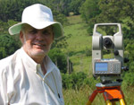
The survey field work for the control traversing, with measured lines of up to 12 kilometres plus to a bank of 9 circular reflecting prisms, was undertaken in 3 basic stages. Firstly – reconnaissance, secondly – marking geodetic control stations on the ground with minor vegetation clearing if necessary, and thirdly – field survey observations for angular and distance measurements utilising Wild T2, one second of arc theodolite, and Wild D1 20 Distomat infra-red electronic distance measuring equipment, EDM, capable of millimetre accuracy.
A total of 78 new geodetic control survey stations were established on the islands of Upolu, Manono, Apolima and Savaii by myself, in conjunction with Departmental survey field party teams plural, over the period 1983 to 1985. Ground survey control stations were either concrete observing pillars, brass plaques set in concrete with an iron witness post, or galvanised iron pipes set in concrete – dependent on site terrain, accessibility, and distance from the survey vehicle. My survey project measured field observations were recorded in sixteen survey field books, numbered 746 to 761 inclusive, held by the Survey Office, Department of Lands and Surveys, Apia.
I have attached as a PDF, a barely readable copy of the survey plan detailing the overall control traverse network, highlighted in red, completed by myself, over the main islands of Upolu and Savaii, together with measured connections between these islands.
.

Principal senior field survey assistant Taofia, who assisted me throughout the whole of this project.
“Manuia le ta’avale, Robarti”
.
Island circumference Geodetic control traverses were independently checked by solar astronomical azimuth observations on specified traverse lines on both Upolu and Savaii. Measured traverse loops survey miscloses were checked by plane projection coordinate computations, and met standard specified criteria. The Savaii traverse loop perimeter was a total length of 174.4 kilometres.
Additionally, the computed Geodetic latitude and longitude of my control traverse points, were compared with the six previously established Doppler satellite stations’ coordinates, undertaken by the Royal Australian Survey Corps on Upolu and Savaii in 1982. Acceptable minor differences were noted between these two seperate Geodetic surveys.


Left – Samoan Survey Technician, Finauga, operating Wild T2 instrument and Wild D1 20 Distomat EDM, on top of concrete survey pillar, Geodetic control traverse survey station, Upolu. Top right – Field assistant with erected over the station mark, bank of 9 circular reflecting prisms, for EDM distance measurement.

Toyota Hilux 4WD survey vehicle, tailgate down, and field staff, on the vehicular and passenger ferry travelling from Mulifanua Wharf, Upolu, to Salelolonga Wharf, Savaii. A 24 hour plus wait to get the vehicle on this ferry.
.


________
Top left – Arriving at Apolima Island Top right – Guest accommodation fale, Apolima Island


___________
Top left – Samoan Matai’s daughter on Apolima Island Top right – Survey field party leaving Apolima Island
Apolima Island is the rim of an old extinct volcanic crater.
.
Necessary complex Geodetic and map projection coordinates computations and adjustments, were undertaken on an Apple IIe computer, with Geodetic and mapping software provided by Scientific Software, Brisbane, Australia.
The Universal Transverse Mercator Projection on the WGS 72 spheroid, with a 6 degree zone width, was the basis for the computation of coordinates on the UTM grid for the Geodetic control traverse survey of Western Samoa. An alternative map projection, which may have been more suitable for Western Samoa, in consideration of the shape, location and size of the two main islands, was a Transverse Mercator Projection with a 2 degree zone width. Final adopted mapping coordinate data was supplied for both the 6 degree and 2 degree zone widths. Refer to extract of data shown below. Note, the Geodetic software provided at the time could not compute west longitudes, and accordingly, they are described in the data in an east format.
An extract of the title and contents only of my final submitted comprehensive written report, of my project involvement, is attached as a PDF.
.

Extract of stations’ summary of Geodetic control data for part of Savaii – Geographics, Latitudes are south, Longitudes are east – Transverse Mercator Projection grid coordinates east and north, Zone is 2 degrees width, Central Meridian 172 degrees west, Zone 5, World Geodetic System 1972 spheroid. WGS 72.
.

Robert undertaking precision angle observations with the Wild T2 instrument at a Geodetic control traverse station on Savaii. This station was located on an old black volcanic lava field in close proximity to the ocean coast. Note the white large surf spray in the background. My Samoan field assistant is booking my readings to the field book, whilst holding one of the Tait 2-way communication radios. Access to this station necessitated a 3 hour walk from the survey vehicle, which was left at the nearest trafficable road. Photo was taken by Taofia.
__________________
O loʻu loto fa’afetai tele i aʻu uo uma Samoa.
Fa’afetai i mea uma mo nei tau taua.
Loʻu taimi ma loʻu aafiaga i Samoa e leʻi faagaloina.
~ Robarti
___________________
Fai le la ! Lelei le matagi !
Make sail ! The winds are fair !
____________________
.
Acknowledgements:
The Australian Government through ADAB, provided all Geodetic measuring equipment, Apple IIe computer, Geodetic computation software, Toyota Hilux 4WD vehicle, and an aluminium dinghy with outboard motor for this project.
The assistance of Tony Godfrey-Smith, Resident Australian High Commissioner to Western Samoa, during my project period.
Without Gillian’s eyes and dedicated and passionate involvement, this article would not have been produced. Malo tele lava Gillian. Special thanks to our son Sam for helping to restore some of the old damaged photos.
References:
Western Samoa – The Land, Its People, The Way of Life, Cradle of Polynesia, Western Samoa Visitors Bureau publication, 18 November 1981.
Manual of the New South Wales Integrated Survey Grid, NSW Department of Lands, Sydney, January 1976.
Stevenson, Robert Louis, A Footnote to History – Eight Years of Trouble in Samoa, Pub. 1912, Swanston Edition.
Stevenson, Robert Louis, In the South Seas, Pub. 1924, Chatto & Windus, London.
Turner, George, Samoa, a Hundred Years Ago and Long Before, London Missionary Society, First Pub. 1884, London. Ebook – Project Gutenberg, 1 Dec. 2004.
The Cyclopedia of Samoa, Illustrated. Published under the Patronage of His Excellency Dr Solf, the Governor of German Samoa, 1907, Sydney, McCarron Stewart & Co.
Irwin, George, Samoa – A Teacher’s Tale, Pub. 1965, Cassell, London. Maps provided above sourced from this pub.
Freeman, Derek, Margaret Mead and Samoa – The Making and Unmaking of an Anthropological Myth, Pub. 1983, Australian National University Press, Canberra.
Holmes, Lowell D., Quest for the Real Samoa, Pub. 1987.
Barr, Donna Marie, My View From the House by the Sea, Pub. 2022, White Hawk Press.
.

Time out for Robert and Gillian on Upolu.
.

Robert produced this posting with Gillian, as part of his personal therapy, while recovering from an Ischemic stroke.


