An insight into an original NSW Crown Portion Survey and Plan
An investigation using primary Crown Portion 13, Parish of Clunes, County of Rous, in the Byron Shire. Located at Nashua between Bangalow and Lismore, far northern New South Wales.
“ Within days of him ( Bligh ) moving into Government House ( 1806 ), Governor King made three land grants to ( Governor ) Bligh : 240 acres on the southern fringe of the ( Sydney ) settlement, 105 acres near Parramatta and a 1000 acres near Rous Hill.” ~ Mundle, Rob. Bligh : Master Mariner. pp 326, Sydney, Hachette Australia, 2010.
“ Of course this was not the land of no one. It could never have been terra nullius. This is just historically wrong. Therefore, if it was a land of someone, that someone, their customs and traditions were as much a source of common law as European custom and tradition had been, informing the body of Australian common law and in that law, there’s a title. It’s called Native Title.” ~ Paul Keating, Australian Prime Minister 1991-1996, interview for ABC Television – 100 Years the Australian Story, 1997-2001.
.
In the beginning - The origin of Crown Land in New South Wales, Australia
Prior to the establishment of a penal colony at Sydney in 1788 by Governor Phillip, the Australian continent had been occupied by the indigenous owners for many thousands of years. The land for this penal settlement was just appropriated – with possession claimed by Governor Phillip on behalf of the British Government, in the name of the Crown, hence the terminology Crown Land. No consultation regarding land ownership took place with the local Aboriginal inhabitants at this time. On British settlement in NSW, the resulting colonial government claimed all lands for the Crown. Being instructed from Britain, early Governors of New South Wales were empowered to make land grants to free settlers. The Surveyor General’s office was created to administer Crown Lands.
Today, Crown Land in NSW is land owned by the State government on behalf of the people of NSW and is under the care and control of the Minister for Lands.
Extracts from Crown Portion 13, Parish of Clunes, County of Rous
click on diagrams to enlarge
100 Links = 1 Chain = 66 Feet = 20.1168 Metres ~ . 200 Acres = 80.937 Hectares
.
The sale of Crown Land to the private sector and the Crown Portion 13, Plan of Survey
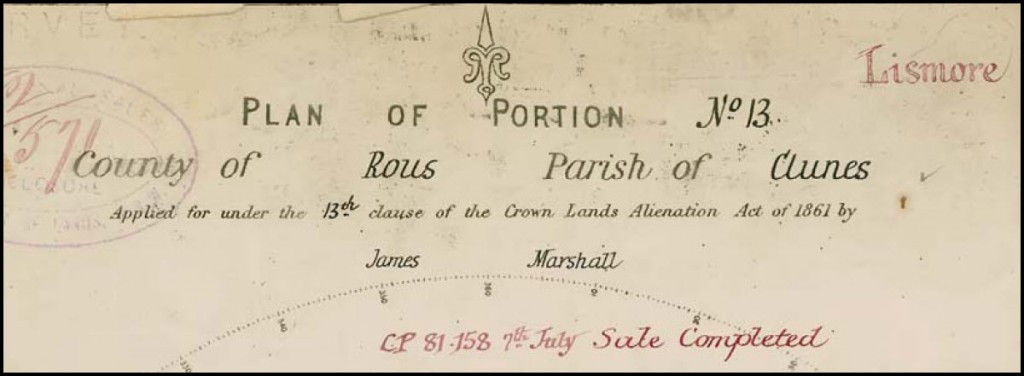
The title heading of the Portion 13 plan of survey indicates that James Marshall applied for this 200 acre land parcel under the 13th Clause of The Crown Lands Alienation Act of 1861, also known as The Robertson’s Alienation Act. Clause 13 introduced the alienation of Crown Land under the concept of conditional purchase (CP). Alienation of Crown Land in the sense of the transfer of title and possession of real property. This Act also allowed for land areas to be selected before survey, as the number of qualified and capable land surveyors available was limited at this period. The freehold title to land being granted, subject to fulfilling a specified set of conditions, usually in the form of making certain improvements, remaining on the land for a specific period of time and meeting a payment schedule. After 1831 there were no free land grants.
The red ink notation shown within the Portion 13 land parcel indicates that William Baker subsequently bought this property under conditional purchase, CP. 81.158, and conditional sale No. CS 07.49273, confirmed by issued Crown Grant Volume 1860 Folio 224, and verified by notations on the Clunes Parish Map. The Crown Grant being a legal document providing evidence to freehold land title, for what was formerly Crown Land, similar to the modern Certificate of Title.

FORMER BRITISH EMBLEM ON NSW TITLE "Dieu et mon droit " The motto of the British Monarch referring to the divine right of the Monarch to Govern.
Limits of land ownership and the delineation of Portion 13 land boundaries on the ground
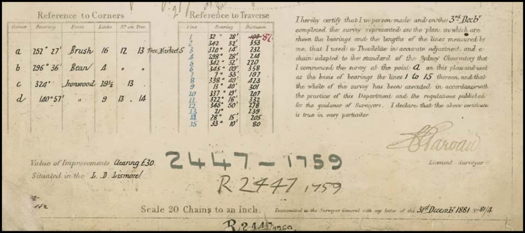
Original Portion surveys and associated Crown Portion Plans define alienated, or capable of being alienated, Crown Land. The title diagram referred to in the Crown Grant for Portion 13, is the Crown Plan of Portion 13, with a Crown Plan 2447-1759 reference number. The small number 1759, indicates that this Portion plan is within the County of Rous.
The field survey for Portion 13 was completed by Licensed Surveyor, Mr. C. F. Garvan in December 1881, in accordance with ” the practice of this Department ( NSW Lands ) and the regulations published for the guidance of Surveyors “, and as dutifully stated by the Surveyor’s declaration in the lower right hand corner of the plan.
Land boundaries were necessarily required to be discernible on the ground to the new land owner.
Current NSW land boundary survey practice requirements are known as the Surveying and Spatial Information Regulation 2006.
Land boundary survey of original Crown Portion 13
Mr. Surveyor Garvan’s task was to undertake both precision length ( in links ) and angular measurement land surveying, to set out an exact 200 acre land parcel, incorporating a separate road reserve and a Wilsons Creek bank boundary. Survey computations, using trigonometrical tables, confirmed to the Surveyor what boundary lengths to adopt to lay out the correct land area. The portion boundaries were orientated on the cardinal ( 0° or 90°, north and east ), approximate orientation to Magnetic North, with no bearings shown on the cardinal lines on the portion plan.
Ground survey markings wholly determined the land boundary locations, which were not related to the true north meridian.
Within the measured Portion 13 Plan, part of the terrain, in 1881, is described as ” mountainous dense cedar scrub “. The earliest settlers to the Bangalow, Byron Bay and Mullumbimby hinterland were not seeking a seachange, but rather, attracted to the financial rewards of logging the valuable natural red cedar timber resource.
Subtropical heat, intermittent rain and insects, bush camp living, travel by horse was the survey field party’s continuous experience, when surveying land boundaries with link chain and theodolite, in the sometimes challenging NSW far North Coast Big Scrub terrain.
The survey field party, comprising of several chainmen and axemen, led by Licensed Surveyor, Mr. C. F. Garvan, measured and marked the land and road boundaries, as required by the existing Survey Regulations, and additionally, located the position of the creek boundary bank to cardinal boundarys by survey traverse. The mathematical accuracy of the overall survey, in compliance with existing regulations, could be tested by closure computations of measured bearings and distances. The tabulated creek traverse shown on the portion plan has a red ink amendment for traverse line number one.
For future reinstatement, the main pegged and lockspitted portion corners were connected by survey to specially marked reference trees. For example, at the north west corner of Portion 13, noted as ” C “, a reference Ironwood tree was cut with a horseshoe shield, marked with a government broad arrow and the number 13. From the broad arrow point to the actual true portion corner, being a measured bearing of 324°00′ and horizontal distance, 19.5 links. The Portion 13 cardinal boundary lines were blazed, the purpose being to physically locate the land boundary position in thickly timbered country. With reference to the tree diagram, existing trees on the boundary line were double blazed on both sides and trees within two paces of the boundary, with a single blaze, being a horseshoe shield cut into the trees.
What is the relevance of the 1881 Crown Portion survey to this Land Surveyor in 2011 ?
Today, evidence of the original boundary survey markings of the 1881 survey are long gone. Registered Deposited Plans of Survey ( DPs ) indicate that Portion 13 has been subsequently subdivided on three separate occasions. Recently, I was requested to locate and mark part of the still existing unconstructed crown road reserve in relation to the old southern boundary of Portion 13. None of the more recent DPs detailed the road boundary bearings and distances. That necessary information could only be obtained reliably from the original Crown Portion 13 Plan.
Existing land boundaries prior to the Colonial initiated Crown Portion Survey and Plan
” Over thousands of years Indigenous people have lived in Australia developing a unique system for signposting and marking the land. This system is interconnected with stories of the Dreaming and Spirit Ancestors. Indigenous people use natural features of the landscape to identify and mark the land and its significance. Many Indigenous children learn these “mental maps” of their countries and about how places relate to each other and to people.” ~ The Australian Museum, The Land, Indigenous Land Use.
.
The dispossession of indigenous land by the colonisation of NSW in 1788, was partly redressed with the introduction of the NSW Aboriginal Land Rights Act 1983. Local Aboriginal Land Councils were offered the opportunity to make formal claims for particular Crown Lands. Under Clause 36 of this Act, claimable Crown Lands were lands ” vested in Her Majesty “, unalienated Crown Land, not lawfully used or occupied, or not needed or are likely to be needed as residential lands, or not needed for an essential public purpose. Under this legislation, many successful claims have been determined, inclusive of old crown portions, which have been transferred to Land Councils for their use and control.
“ He selected on a run at Dry Hole Creek, and for months awaited the arrival of the Government surveyors to fix his boundaries; but they didn’t come, and, as he had no reason to believe they would turn up within the next ten years, he grubbed and fenced at a venture, and started farming operations. “ ~ Settling on the Land ~ Henry Lawson – 1893 ~ Lawson, Henry, A Camp Fire Yarn, Complete Works 1885-1900.
.
Should you have any enquiries concerning land boundary survey in the Bangalow, Byron Bay or Mullumbimby hinterland, I offer as an experienced New South Wales Registered Land Surveyor, personal professional service and expert friendly advice, leading to successful client outcomes.
NEW SOUTH WALES NORTHERN RIVERS REGION - AUSTRALIA
BYRON BAY – BANGALOW – MULLUMBIMBY – BRUNSWICK HEADS – WATEGOS BEACH – ST. HELENA – OCEAN SHORES – SUFFOLK PARK – FEDERAL – WILSONS CREEK – BALLINA – LISMORE – TWEED HEADS – MURWILLUMBAH – LENNOX HEAD – TINTENBAR – CLUNES – BEXHILL – COORABELL – POSSUM CREEK – MYOCUM – EWINGSDALE – WANGANUI – GOONENGERRY – COOPERS SHOOT – EUREKA – MAIN ARM – CRABBES CREEK – YELGUN – CASINO – NIMBIN – BURRINGBAR – UKI – BILLINUDGEL – POTTSVILLE – WOLLONGBAR – ALSTONVILLE – MOOBALL – KYOGLE – HUONBROOK – NASHUA
Please visit my website for contact details.
An explanation of the above land related terminology, may be found in a glossary provided by the New South Wales Land and Property Management Authority (NSW LPMA).
.


