Surveying computations and the land boundary Surveyor
The cadastre of the Bangalow, Byron Bay and Mullumbimby districts is made up of numerous urban and rural land parcels, whose perimeter land boundary dimensions have been tested.
Created man-made ownership land boundaries have a fixed permanent location on the ground. Natural land boundaries, for example a creek bank, may vary in ground location subject to gradual and imperceptible accretion or erosion, over a period of time.
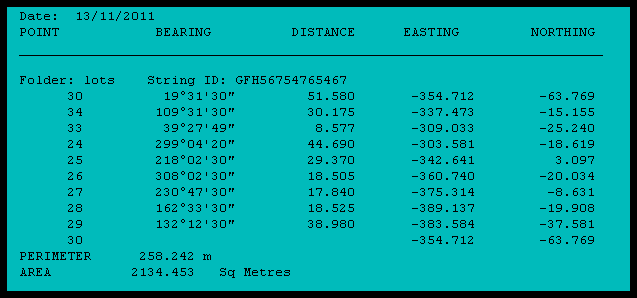
This practising land boundary Surveyor is necessarily preoccupied with surveying computations / calculations, related to land boundaries. The certificate of ownership or title to land, specifies the title diagram, which delineates the external perimeter dimensions of the subject land parcel. In New South Wales ( NSW ), this diagram is usually a numbered and registered deposited plan of survey ( DP ), showing bearings and distances associated with urban or rural lots in the DP.
A former practice, now not commonly used in NSW, was to additionally provide as part of the land title documentation, a written legal metes and bounds description of the boundaries of a land parcel. Subject land perimeter boundary bearings and distances could be extracted for checking, together with measured connections to existing property features ~
“ Lot 3 commencing at a point on the northern side of William Street distant westerly 100 feet from its intersection with the western side of John Street and being the south-western corner of Lot 2 and bounded on the east by the western boundary of Lot 2 aforesaid being a line partly fenced and partly passing along the western face of a brick wall and bearing 0 ° 00′ 150 feet 0 inches to the northern boundary of the subdivided land thence on the north by part of that boundary being a fenced line bearing 270 ° 00′ 50 feet 0 inches to the north-eastern corner of Lot 4 thence on the west by the eastern boundary of Lot 4 aforesaid being a fenced line parallel to and 10 feet distant from a brick wall and bearing 180 ° 00′ 150 feet 0 inches to the northern side of William Street aforesaid and thence on the south by that side of that street bearing 90 ° 00′ 50 feet 0 inches to the point of commencement. “
The Definition of Boundaries, Handbook for Practising Land and Engineering Surveyors, H.G. Foxall.
Essential mathematical land surveying computation checks ~ lead to proof of correctness.
The integrity and correctness of land boundary measurement data as shown in the modern DP, are able to be checked by survey close computation. Field survey measurements, both bearing and distance, are also required to be tested and checked for accuracy, when locating existing ground boundary marks, when setting out new boundary corners, associated reference marking, boundary line marking or when making mandatory surveyed connections to the NSW state survey control mark system ( SCIMS ).
For the purpose of verification closure computations, related to checking land boundary measurements and in the determination of the relationship of building improvements to boundaries, modern technology land surveying software, in various hardware formats is available, both for the office and field.
For example, COGO and CAD computer software for the office PC, and for field use, sophisticated hand-held programmable calculators, for ease of portability and additionally for data transfer, to and from the PC.
Prior to electronics ~ no cabling or batteries required !
Before the widespread introduction and use of personal computers and programmable hand-held devices, how did the land surveyor undertake necessary surveying computations ? ~ Very slowly. ~ Hand written proformas, using a book of trigonometrical tables, in conjunction with a mechanical calculator, achieved the result of confirming the correctness and accuracy of land boundary measurement survey data. In my experience, for office use, the mechanical calculator of choice for land surveyors in the early 1960s was the FACIT, which used a numeric metal key layout and a rotary setting lever.
For survey field use, the CURTA, made in Liechtenstein, was the preferred mechanical calculator. See pictures below. It was elegant, compact, portable, able to be held in one’s hand and housed in a small water proof metal canister. Used with a pocket book of trigonometrical tables, necessary survey computations could be undertaken on the spot in the field. To get an idea of the size and scale of the CURTA, the ring tab as seen in the photos below accommodates the point of one’s finger, which permits the clearing of data to allow for a new computation.


The methodology of land surveying computations and the impact on the cadastral layout pattern.
The advent of modern computer technology coupled with electronic field measuring equipment permitted a more complex layout of the urban and rural land subdivision pattern, in sympathy and integrated with, the contours and features of the landscape. This new computerised technology removed the burden of laborious, by hand, land surveying computations.
The early subdivision pattern of older NSW towns and rural areas, dominated by the adoption of right angled grid layouts, was partly created because of existing limitations with respect to land surveying computation technology. This land rectangular grid layout facilitated easier survey computations, both in the office and the field, but additionally at times, took no account of the topography of the land. Field land surveying techniques were developed to avoid computations by predominantly working with right angles and parallel offsets, where land boundaries were occupied by fences, walls, trees or vegetation. The original township of Mullumbimby, first surveyed in the 1890s, was set out on this rectangular grid pattern.
Checks, proofs and resultant certainty in modern land boundary determination.
Ultimately, the evidence of survey markings, cadastral monuments and improvements on the ground, related to the relevant registered plan of survey, DP, locates the correct position of a land boundary. Precision field measurement, coupled with investigative surveying computations, facilitates a proper comparison with measurement data detailed and shown on a DP, to actual measurements between found points and / or survey marks on the ground.
A cadastral monument is a natural or artificial object, point, or survey mark, stable in the ground, which is used for the purpose of locating or relocating a land boundary, and must be documented and referred to in a registered plan of survey or legal document on public record.
Through surveying computations, the adoption of a reinstated land boundary position, is supported and proved by measured comparison connections to other survey markings found. The final boundary measurements determined and adopted, may not necessarily be in exact agreement with the base DP data. The accepted rule of law, is that if the position of found undisturbed cadastral monuments conflicts with measurements shown in the original registered DP, then the doctrine of “monuments over measurements ” applies.
A good starting point for finding online resources for land surveying computation software, applicable for both the office and field, can be found at .. Land Surveying and Geomatics Software.
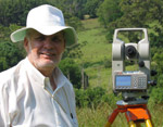
Should you have any enquiries concerning land boundary investigation in the Byron, Ballina, Lismore or Tweed Shires, I offer as an experienced New South Wales Registered Land Surveyor, personal professional service and expert friendly advice, leading to successful client outcomes.
NEW SOUTH WALES NORTHERN RIVERS REGION - AUSTRALIA
BYRON BAY – BANGALOW – MULLUMBIMBY – BRUNSWICK HEADS – WATEGOS BEACH – ST. HELENA – OCEAN SHORES – SUFFOLK PARK – FEDERAL – WILSONS CREEK – BALLINA – LISMORE – TWEED HEADS – MURWILLUMBAH – LENNOX HEAD – TINTENBAR – CLUNES – BEXHILL – COORABELL – POSSUM CREEK – MYOCUM – EWINGSDALE – WANGANUI – GOONENGERRY – COOPERS SHOOT – EUREKA – MAIN ARM – CRABBES CREEK – YELGUN – CASINO – NIMBIN – BURRINGBAR – UKI – BILLINUDGEL – POTTSVILLE – WOLLONGBAR – ALSTONVILLE – MOOBALL – KYOGLE – HUONBROOK – NASHUA
Please visit my website for contact details.
An explanation of the above land related terminology, may be found in a glossary provided by the New South Wales Land and Property Information ( NSW LPI ), Registrar General’s Directions.
…….


