Affordable land at Wategos Beach, Byron Bay, NSW, in 1961
Future options for land affordability from a Surveyor’s perspective in the Byron Shire & beyond
Some background information ~ Income and Costs for the period 1960 to 1962
- Sydney, New South Wales, basic adult male wage 1960, £14.7 Pounds. Affordable Housing in NSW, Past to Present, NSW Parliamentary Research Service , November 2005.
- Average adult male weekly earnings, all industry groups, Australia, October 1961, about £21 Pounds. Official Year Book of the Commonwealth of Australia No. 33. By Australian Commonwealth Bureau of Census and Statistics.
- Average weekly earnings per male unit, NSW, for the year 1961 – 62, £24.51 Pounds. Official Year Book of New South Wales, No. 57 (1961), National Library of Australia.
- Cost of brand new 8′ 6″, 2 stringer, Barry Bennett Malibu surfboard, 1962, £38 Pounds 10s Shillings. Correspondence with Barry Bennett, Bennett Surfboards P/L..
- Cost of an allotment of land, Wategos Beach, Byron Bay, NSW Department of Lands, Crown Lands Subdivision, first auction, 25 November 1961, about £350 Pounds and less. NSW Government Gazette, 20 October 1961, pp. 3298-3299. Local anecdotal evidence and 2010 newspaper article published online.
Left click to enlarge photos
Movie screenshots from Bruce Brown’s movie “Surfing Hollow Days” - filmed in 1961 and released in 1962, showing the Wategos Beach locality, Byron Bay, in 1961. The two movie stills show the initial preparation of the engineering road works for the Wategos Beach Crown Lands subdivision. Fifty years ago in 2011. Left picture, Julian Rocks is in the background.
.
A New South Wales Government Initiative 1961
The Wategos Beach Crown land subdivision was a NSW Government development commenced by the Lands Department in about 1961. Several land sale auctions took place, the first being undertaken on 25 November 1961. As evidenced by income and costs, almost fifty years ago, land at Wategos Beach, Byron Bay, could be construed to be accessible and affordable to the broader local community in 1961. Today, property is exchanged at Wategos Beach in the multi million dollar range. I speculate that current existing NSW State and Local Government land use planning and environmental protection regulations, probably, would not have allowed this land development to proceed today.
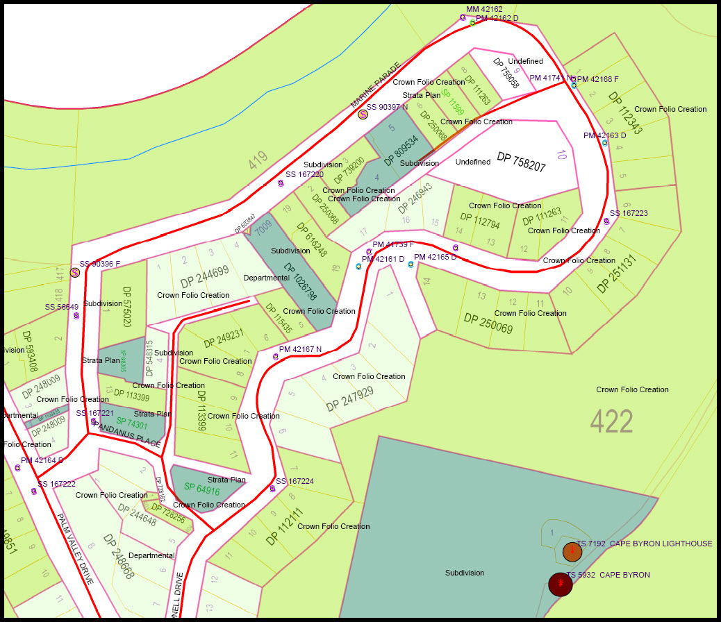
Wategos Beach Crown Lands Subdivision, showing allotments, sections and administrative notations. Extract from NSW Department of Lands, Town of Byron Bay, Sheet 1, Status Branch Charting Maps. Orientation magnetic north.
Wategos Beach Crown Lands Subdivision showing Deposited Plan numbers, allotments and survey control points.Trigonometrical station, Cape Byron Lighthouse, lower right hand corner. Source NSW Land and Property Management Authority (LPMA), February 2011. Orientation MGA Grid North.
.
Future options for consideration ~ Land cost ~ the key determinant, leading to “affordable housing “.
- The land policy makers to release more land stock for urban and rural housing. By increasing the supply, demand may be dampened and land prices stabilised or reduced. Create more choice and competition in the urban and rural housing mix.
- Today’s younger community is becoming disenfranchised with respect to land and home ownership. New models for urban and rural housing are required. For selected and appropriate locations, lessen the requirements for land subdivision utility infrastructure, reduce building structure requirements, both without compromising personal safety, control Local Government fees and limit development conditions of consent, with a view to providing genuine “affordable housing” offering the security of an individual land title to a property owner.
- Permit building entitlements for selected closed Crown and Council roads.
- Assess the opportunity of developing Crown Land for affordable housing by way of Conditional Purchase, title being granted on a set of conditions being met – eg. the owner to reside on the land, minimum building improvements to be constructed within a set time frame and the land not to be sold for a specified number of years.
- Revisit and reintroduce a new form of the previously successful NSW Concessional Allotment Scheme, which enabled a rural land owner to subdivide a specified number of lots smaller than the allowable subdivision requirement, from the existing holding. Each new subdivided lot having a building entitlement. Place initiative in the control of the land owner and the community. This proposed scheme would not be applied to and exclude, environmentally protected and hazardous lands.
- In the Byron Shire, under the Interim Development Order No. 1, 1968, about 1200 concessional allotments were created during the period 1968 through to about 1986, when this provision was closed and replaced by the Byron LEP 1988. ( Byron Rural Settlement Strategy 1998, Incorporating Best Practice Guidelines and Performance Standards, Page 15.)
Perhaps my recommendations may be wishful thinking, however, their consideration at least may promote further investigation and much needed action in this important issue.
Should you have any enquiries concerning land boundary survey in Byron Bay or the surrounding hinterland, I offer as an experienced New South Wales Registered Land Surveyor, personal professional service and expert friendly advice, leading to successful client outcomes.
NEW SOUTH WALES NORTHERN RIVERS REGION - AUSTRALIA
BYRON BAY – BANGALOW – MULLUMBIMBY – BRUNSWICK HEADS – WATEGOS BEACH – ST. HELENA – OCEAN SHORES – SUFFOLK PARK – FEDERAL – WILSONS CREEK – BALLINA – LISMORE – TWEED HEADS – MURWILLUMBAH – LENNOX HEAD – TINTENBAR – CLUNES – BEXHILL – COORABELL – POSSUM CREEK – MYOCUM – EWINGSDALE – WANGANUI – GOONENGERRY – COOPERS SHOOT – EUREKA – MAIN ARM – CRABBES CREEK – YELGUN – CASINO – NIMBIN – BURRINGBAR – UKI – BILLINUDGEL – POTTSVILLE – WOLLONGBAR – ALSTONVILLE – MOOBALL – KYOGLE – HUONBROOK – NASHUA
Please visit my website for contact details.
An explanation of the above land related terminology, may be found in a glossary provided by the New South Wales Land and Property Management Authority (NSW LPMA).
.
.


